Envisioning Urban Environments Resilient to Vector-Borne Diseases: A One Health Approach to Dengue Management
1. Problem Statement
The world’s population will reach 8 billion people during 2022, exceeding 9.7 billion by 2050. This global communities increasingly live in urban environments, with a predicted rise from 56% of inhabitants currently to 70% by 2050 [6.1]. This rapid growth in urban population density poses significant risks for the spread of vector-borne and other infectious diseases to human residents of metropolitan areas. This proposal asks the following important question: is there a way to improve the urban environment to significantly reduce or eliminate the spread of vector-borne diseases, in particular mosquito-transmitted Dengue virus? The key argument is that while our built environments have become sufficiently resilient to provide protection from natural infractions such as rain, heat, cold, earthquakes, etc., and offer security from externalities such as violence, could we also envision designing them for protection against infectious diseases by considering both indoor and outdoor environments as a whole?
We will answer this question by understanding the spread of vector-borne diseases, such as Dengue, from a One Health perspective, that is, the recognition of the interdependence between humans, animals, and ecosystems through their shared (built) environment. As a result, we can achieve better outcomes in controlling or eradicating these debilitating diseases. This viewpoint is particularly important because
climate change is likely to significantly impact these interdependencies by altering the persistence of ponded water in which juvenile mosquitoes develop due to increasing temperature and shifting rainfall patterns with regard to magnitude, duration, frequency, and persistence (1,2,3), and can therefore worsen the incidence of Dengue. Considered to be among the most problematic mosquito- borne diseases of humans, globally Dengue virus causes 50-100 million symptomatic cases each year, with an estimated 70% occurring in Asia (4). In 2013, the global economic burden of Dengue was estimated at about 8.9 billion USD ( 5). In Vietnam and other tropical and subtropical countries, Dengue is increasingly prevalent in cities and suburbs (4, 6), rather than rural areas, as the predominant Aedes species mosquitoes that transmit the virus have a predilection for peridomestic settings (7). Estimated yearly infection cases in Vietnam are 2 million, leading to between 30 to 95 million USD in economic impacts (8, 9). The proposed research is significant to fast-growing economies, in particular to Vietnam, because of rapid urbanization. The project outcomes will offer immediate opportunities for implementation of strategies to positively impact the society. Discoveries that contribute to reducing disease transmission in the context of the built environment will provide tremendous value to the people of Vietnam and serve as a model worldwide.
We aim to develop a comprehensive modeling framework to predict the risk of Dengue infection in Vietnam. We envisage that this project will pioneer a new way of approaching smart health by developing preventive and predictive approaches for urban planning and learning continually using data from Vietnam’s rapidly expanding urban development (VinHomes providing prime examples of this in locations across the country). The proposed framework for smart health will deploy computational approaches, including both process-based numerical simulation and ML/AI (Machine Learning/Artificial Intelligence), to develop long-term design strategies through adaptive learning from environmental surveillance and epidemiological data in (available from VinMec and the Ministry of Health) for model validation.
We will create digital twins of the urban environment, which receive sensor data for factors influencing Dengue transmission, such as temperature, humidity, and CO2 concentration. Our model will predict infection risk level in real-time and make corresponding public health recommendations for risk reduction. We believe this project will have an immediate and significant impact on future planning of Vietnam’s rapidly increasing urbanization in line with its fast rate of economic growth. Moreover, the outcomes will have broad applicability in tropical and subtropical zones across the world where Dengue is prevalent. At present, approaching half of the world population lives in these regions, so are potentially at risk from infection
2. Research Tasks
We propose four research tasks that will be conducted in parallel and the findings from each task will
help to refine other tasks. First, we will develop a neighborhood scale computational model, with the aim to expand to town/city scale, to predict Dengue virus transmission under different climate scenarios (Task 1). Second, we will collect disease incidence data and mosquito abundance data from the selected locations to refine the model (Task 2). Third, we will collect empirical data to understand how different types of interventions are related to disease prevalence and mosquito abundance (Task 3). Findings from Task 1 will guide the data collection in Tasks 2 and 3. Fourth, we will develop a large-scale model to describe air flow and thermal conditions in selected urban developments and then use machine learning to develop a surrogate model for a digital twin of these developments. We will also set up online sensors for temperature, humidity and wind speed and link the sensing data to the digital twin. The combination of modeling, empirical data for disease incidence and mosquito abundance, and real-time sensing will allow the digital twin to predict the disease risk level and recommended intervention strategies.
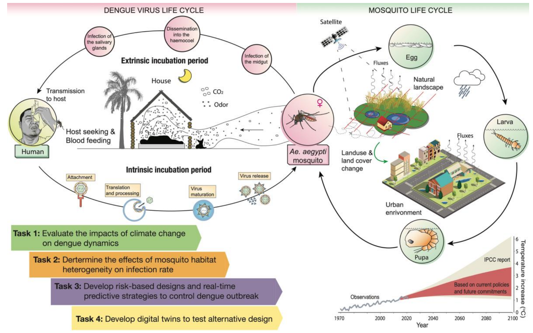
Fig 1. Life cycles of Aedes mosquitoes and Dengue virus and proposed tasks. Dengue virus is transmitted to hosts through saliva by an infectious carrier mosquito when blood-feeding. The virus then advances through several stages inside the mosquito, where the Dengue virus continues developing with a degree-day air temperature dependence until the mosquito becomes infectious to humans. Climate change, as manifested through elevated atmospheric CO2, higher temperature, and altered precipitation magnitude, induces changes in hydrologic variability. Changing landscape, from natural to urban environments, may affect local weather more acutely than long-term climate change. Along with socioeconomic activities, these processes have myriad potential impacts on Dengue transmission
Task 1: Evaluate the impacts of climate change on Dengue dynamics [Kumar, Le and Allan]
The transmission cycle of Dengue is markedly complex, involving two different replication cycles of Dengue virus alternating in human hosts and Aedes species mosquitoes (Fig. 1). These cycles are often controlled by fluctuations dominated by the random nature of population events (e.g. mosquito dynamics and human mobility) and the space-time variability of suitable environmental conditions. The development of Dengue virus inside adult mosquitoes, which are ectothermic or cold-blooded insects, is air-temperature dependent and expected to be affected by global warming. Current evidence suggests that future climate change and variability, particularly with more frequent extreme events, may amplify Dengue transmission (10, 11) through influence on increasing mosquito abundance, higher biting and survival rates of mosquitoes, and shorter Dengue virus extrinsic incubation period – the duration between the time when a mosquito takes a viremic blood meal and when that mosquito becomes infectious.
Based on our previous work (12), we will develop a stochastic lattice-based integrated Dengue model to predict the dynamics of Dengue under climate change for the urban environment. The proposed model consists of two time -continuous space-discrete sub-models that consider the nonlinear relationship between temperature and Dengue virus development (including all 4 serotypes) inside the Aedes vectors for estimating the Dengue virus extrinsic incubation period under global warming. It incorporates explicit coupling between entomological and viral processes, epidemiological statuses, and hydro-climatic conditions to capture the dynamics of dengue. The stochastic entomological model resolves the life cycles in aquatic and adult phases of Aedes mosquitoes using the ELPAs (Egg, Larva, Pupa, and Adult) structure. The coupled epidemiology-virology model simulates stochastically the circulation of Dengue virus in human hosts and adult Aedes vectors using the well-known SEIR (Susceptible, Exposed, Infected, and Recovered) approach. These two sub-models will be iteratively coupled in discrete space domains through the equality constraint of adult vector populations. In addition, our model will also incorporate a meta-population approach to describe the spatial movements among discrete geographic domains in urban environments.
The proposed model will move beyond the current state of the art models for vector -borne diseases. Existing models explicitly incorporate the aquatic stage of the mosquito life cycle and the spatial dynamics of mosquitoes, distribution of human population, atmospheric conditions, and hydrological conditions into a susceptible-exposed-infected-recovered (SEIR) epidemics model (12). While such models have improved predictive ability for infection rates, they were not developed to gain insights into interventional approaches by coupling the life cycle of both the vector mosquito and the virus across the horizontal and vertical heterogeneity of the modern, planned urban environment. For planning sustainable and healthy urban environment, we need to incorporate considerations of the role of parks and detention ponds/lakes that support green spaces, the density of population that enables rapid spread of the vector-borne disease and changing micro-habitats of the mosquito life cycle under climate change.
Task 2. Determine how the heterogeneity of mosquito habitat (horizontally and vertically) in an urban environment affect human infection rate [Allan, Taylor-Robinson, and Nguyen]
Aedes aegypti and Aedes albopictus , the main mosquito vectors of Dengue virus in urban environments, are anthropophilic mosquito species. Habitat for the adult life stage of Ae. aegypti, in particular, can be described as the household environment. Gravid adult females lay desiccation-resistant eggs typically in water-holding artificial containers (e.g. buckets, trash cans, and their lids) in and around the home, many of which are small and difficult to detect, making source reduction of juvenile habitats in urban environments especially challenging. Mosquito larvae graze on microbial growth in the aquatic environment, which is largely driven by autochthonous inputs of terrestrial leaf litter detritus that may vary considerably in quality for juvenile development and water quality. In areas where electricity and water services are unreliable, households may store water, increasing the likelihood of colonization by Aedes spp. mosquitoes ( 13). Due to variation in reliability of these municipal services, presence of artificial container habitats, and human population density, risk of exposure to Dengue virus has been shown in Vietnam to vary with human land-use gradients (14), socioeconomic gradients (15), and the built environment (16). However, scant attention has been given to the vertical built environment or strategic implementation of stormwater infrastructure to minimize mosquito habitats in tropical urban environments.
This task will collect epidemiological data for disease incidence and field data for mosquito abundance and Dengue prevalence to validate and refine the model developed in Task 1. We initially select two urban centers of Vietnam: Hanoi and Ho Chi Minh City (HCMC), and a third location, Cam Lam, which is under development into a major urban center. Hanoi to the north and especially HCMC to the south are often hotspots of Dengue fever (17). These are cities of several million people, with high population densities, increasingly developed residential and business infrastructure, which also serve as major transportation hubs in Vietnam. The south -central coastal city of Cam Lam, on the other hand, is being developed into a smart city of more modest size (a project driven by the strategic vision and entrepreneurial mindset of VinGroup). These locations have distinct hydroclimatic conditions that may influence mosquito habitats.
Sampling of mosquito juvenile life stages will be accomplished by searching for larval habitats in and around households and public green spaces, including water-holding containers and stormwater habitats, which will be visually sampled for mosquito juveniles and/or dip-sampled and juvenile presence/abundance quantified. For surveillance of adult mosquitoes, we will deploy a combination of traditional ovitraps (18), the BG sentinel trap (19), and the gravid Aedes trap (20), as different trap types may vary in efficacy across environmental contexts. In addition to the traps, we will deploy sensors to measure temperature, humidity,
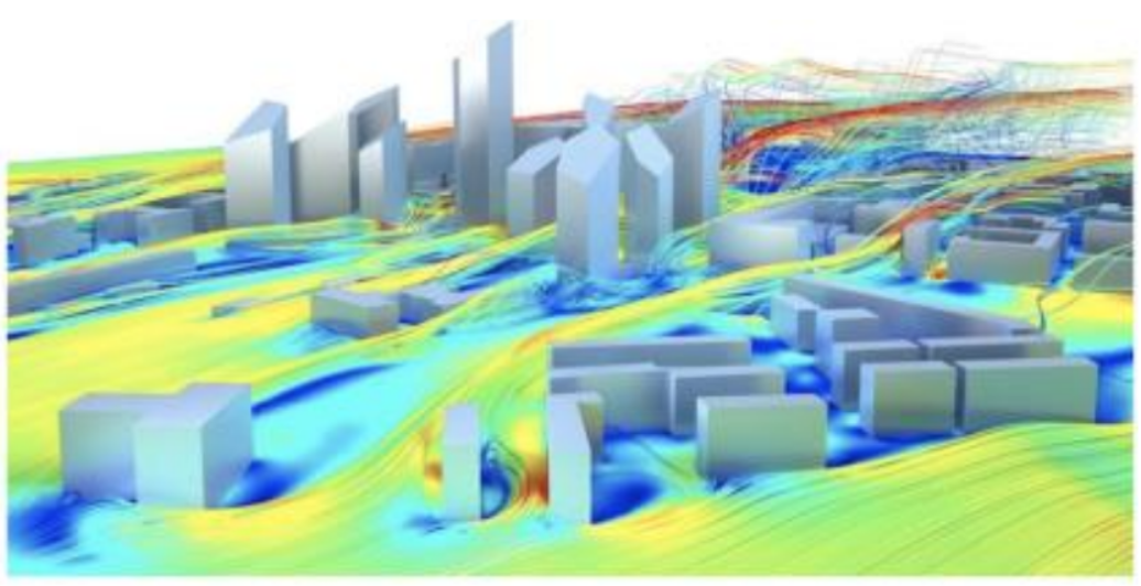
Fig 2. High-fidelity large eddy simulation over an urban landscape. Streamlines are air flow directions and colors denote wind speed.
and wind speed at the sampling sites. It has been shown previously that mosquitoes’ habitats also depend on vegetation and chemical composition of the water ( 21, 22). We will document vegetation (types and coverage) in each sampling area. Water samples will be characterized chemically for ammonia, phosphate, nitrate and pH using field sensor kits, which are frequently used by Nguyen. Sampling frequency will be at least weekly and increased depending on weather conditions. To study the movement of mosquitoes horizontally and vertically in the urban built environment, we will obtain sterilized adult male Ae. aegypti mosquitoes, apply an iridescent dye, and release as part of a mark-recapture study. Sterile males pose no health risk since they will not be able to contribute to mosquito reproduction and only adult females blood feed. Sterile male mosquitoes recaptured at different distances from release points will enable us to model the probability of dispersal distances both horizontally and vertically in the build environment. Past datasets, including mosquito abundance and Dengue disease incidence (weekly and monthly) at sub-province levels, will also be obtained from the Ministry of Health to support Task 1.
Task 3. Develop risk-based design and real-time prediction based interventional strategies control incidence of infection [Taylor-Robinson and Kumar]
Existing survey-based studies, using aggregated counts over large spatial units, are often inaccurate, either over- or under- estimating the effect of a containment measure as such methods assume the instances of activities to be uniformly distributed across entire cities, provinces, or states. Given the localized effectiveness of a single instance of a single containment activity, there is a need for analyses at similarly small (sub-city) spatial resolutions. This project will focus on new urban environments such as those developed in Vietnam by VinHomes. We will collect empirical evidence regarding efficacy of highly localized containment and intervention activities that target vector mosquito species. The findings can facilitate the optimization of real-time prediction-based control and prevention strategies in resource-limited, local level, urban settings.
We will consider the following intervention: managing spatio-temporal distribution of “puddles” in present and future climate, distracting mosquitoes’ ability to seek hosts by disrupting the CO2 gradients that they use to seek hosts, and consideration of stochasticity (e.g., strategies of reducing entrainment of the disease in a domain (neighborhood)). The non-random deployment of each intervention activity in relation to Dengue cases, as well as deployment of organized containment activities in different epidemiological contexts, such as indoor residual spraying and fogging in the vicinity of a residential building, will be accounted for by different modeling frameworks. These will also incorporate individual behaviors regarding such activities as keeping plant pots and other containers in which residual water may collect on apartment balconies at different elevations above ground level to which mosquitoes will have variable access. The predictive results from these spatio -temporal analyses will reinforce existing knowledge from observational data on the efficacy of containment activities aimed at the adult stage of the mosquito life cycle. By applying the model under varying climate conditions, this will inform better building designs and ensure ‘future proof’ urban planning that discourages and distracts mosquitoes from breeding in a peridomestic environment. Mosquito data will be collected as described in Task 2.
Task 4. Develop digital twin to test alternative designs [Yan, Zhao, Nguyen, Allan]
We will build a digital twin by leveraging our newly-developed computational fluid dynamics (CFD)
model to test alternative urban designs. Since the mosquito cannot be treated as a passive scalar field, there is a two-way coupling between their flying behavior and the surrounding air flows. First, a local-scale fluid -structure model (23, 24) will be constructed to characterize the aerodynamic behaviors of mosquito migration first. The flying characteristics will be extracted and fed into a large-scale meteorology-coupled CFD. Second, the high-fidelity meteorology-coupled CFD simulations will characterize the local microclimatic dynamics under different urban configurations. The digital twin will be a large eddy simulation (LES)-based model (Fig. 2) to resolve the atmospheric boundary layer dynamics and meteorology in built environments. These CFD simulations will provide detailed spatiotemporal microclimatic fields and reveal the effects of urban
configuration on their evolutions under both present-day and future climate conditions. We will work with VinHomes to select multiple representative urban types in different geographical regions of Vietnam as test sites for this study. The high-fidelity model will be built on a finite element discretization that can resolve complex urban geometry and incorporating realistic boundary conditions [25, 26, 27]. These LED simulations will be conducted over a domain size of 1 km × 1 km (i.e., neighborhood scale) at the mesh resolution of 1 m, coupled with real-world climate-modeled meteorology. We will use a novel method to validate our simulation. Zhao has recently developed a physics-informed transfer learning framework leveraging satellite imagery, satellite-measured land surface temperature, forcing meteorology data, physics-informed neural networks, and transfer learning techniques to produce urban air temperatures (1,2, 28). This set of high-resolution urban air temperature data will allow us to validate the LES simulations.
The high-fidelity modeled data will be used to predict spatial (both horizontal and vertical) and temporal heterogeneity of mosquito habitats in the urban environment that affect human infection rate. To ensure usability of the digital twin, which needs to be real-time and computationally efficient, we will develop fast surrogate models using physics-informed machine learning [29, 30] by leveraging labeled data generated by the high fidelity model, as recently done by Yan.
We will also setup sensors for temperature, humidity, and wind speed in a few selected VinHomes locations, which are studied in Tasks 2 and 3. The digital twin will provide simulation of Dengue disease risk and intervention strategies in real-time based on the models developed in Task 1, and empirical data collected in Tasks 2 and 3. For locations that have not yet developed (e.g., Cam Lam), the digital twin will allow real time simulation of alternative neighborhood designs to reduce Dengue disease risk.
3. Student & Postdoc Recruitment
PhD students will be recruited in ways that encourage diverse applicants, including announcements through Vietnamese student and scholar networks, universities, and research institutions. During the first 5 years, one PhD and one MS student will be enrolled to work on each of the specific research tasks of the project. An additional PhD/MS/postdoc student to work on the synthesis across Tasks and translation challenges. We will mentor several MS students to go on to become PhD students. Students will be co -advised across disciplines by faculty at UIUC and VinUni and will have at least one of the other disciplines represented on their advisory committee. UIUC will host and grant degrees to 3 PhD and 3 MS students, whereas VinUni will host and grant degrees to 2 PhD and 2 MS students. One postdoc will be recruited during the first 2 years of the project and will be co-advised by PIs at both institutions. We tentatively plan PhD research topics corresponding with the research tasks. Each student will have a primary advisor and a co-advisor. The rest of the team will serve in students’ thesis committees.
4. Research Outcomes
Vector-borne diseases pose a public health threat across the globe. Dengue, Chikungunya and Zika, which are all transmitted by Ae. aegypti, are increasingly prevalent in southeast Asia, and outbreaks of Dengue, Zika, and other arboviruses are becoming more common in the southern and southeastern U.S. We expect that this project will provide a breakthrough in conceptualizing built urban environments in a new way to safeguard against the growing climate change-driven threat of vector-borne diseases. We will disseminate the findings through high profile journal articles and regular presentations at conferences both in Asia and U.S./Europe. We will closely engage with VinHomes group to inform and advise their future residential developments through appropriate technology transfer, and implement new smart health frameworks for integrated data collection and disease management. We will develop approaches for broad adoption of the novel modeling framework so that it can be easily adapted to various climatic and urban development settings. Our group will work actively to seek external funding in both the US and Vietnam. For example, recently established ARPA-H opportunities, NSF, USDA and NIH programs in One Health will be actively pursued. We also anticipate targeting the NSF’s Research Traineeship (NRT) program to develop training for a cohort of students in the proposed thrust.
Pathway to Sustained Collaboration
We view this project as a seed for our UIUC-VinUni collaboration extending in both basic and
translational dimensions. For example, similar modeling frameworks can be developed to guide sustainable and healthy urban development in different locations. For basic research, our collaboration funded through the Smart Health Center will allow us to prepare for larger, external grants on the impact of climate change on human health and necessary adaptation, a scientific field in its infancy. We envision our team to work closely together for translation of the digital twins developed by this research to be used by building managers and public health personnel as a tool to provide real-time mosquito risk levels corresponding to the environmental conditions of buildings and their surroundings. From a practical perspective, we anticipate that each UIUC or VinUni researcher will visit the other campus once a year for 2 weeks, staggered by 6 months. Regular Zoom meetings will be held once every 2 weeks (or 1 month) and students/postdocs will be expected to report on their research. A virtual seminar series will be established to engage with experts external to the UIUC-VinUni research group from both universities